
Try searching for
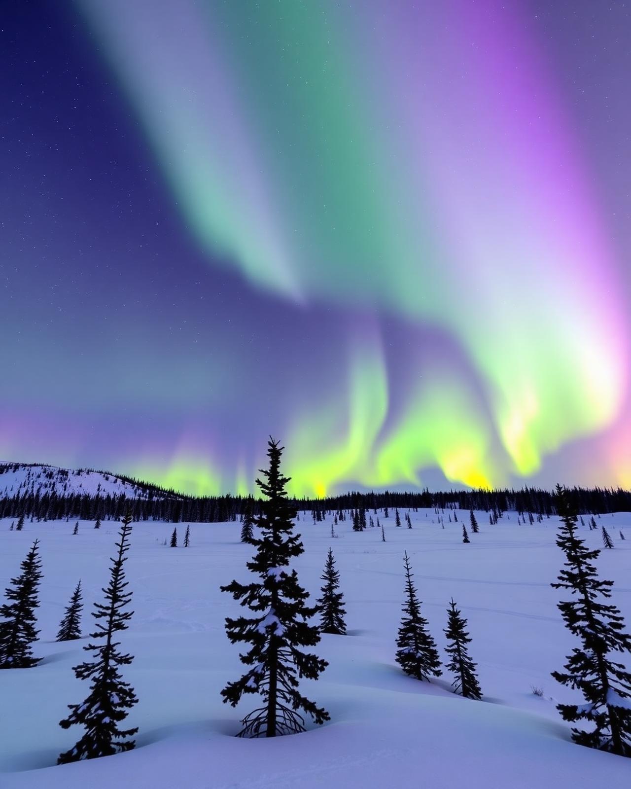
Wilderness drive · Yukon & Alaska
Top of the World Highway
A ridge-top gravel road from Dawson City to Alaska — closed half the year, surreal the other half.
Overview
The Top of the World Highway is the 127-km gravel road that runs from the George Black Ferry across the Yukon River at Dawson City, up onto a ridge that follows the spine of the Ogilvie Mountains, to the Poker Creek border crossing — the northernmost land crossing between Canada and the United States. From there, the Taylor Highway descends into Alaska.
The drive is a Yukon institution. The name says it all — for most of the route, you are on a ridge above the tree line, with views in every direction of an unbroken wilderness that runs to Alaska on one side and the Mackenzie Mountains on the other. The road is unpaved, the views are unobstructed, and the border post (open mid-May to mid-September only) is the smallest international crossing in North America.
Combined with the Klondike Highway south from Dawson and the Alaska Highway from Tok, the Top of the World makes a spectacular loop. Plan the Yukon River ferry crossing carefully — lineups in peak July can be hours long, and the ferry shuts down in shoulder season. The road is closed entirely from late September to late May.
Distance
127 km
Dawson → Poker Creek border
Surface
Gravel
Ridge-top, exposed
Ferry
George Black
Free — Yukon River
Season
Late May – mid-Sep
Closed otherwise
The route
From start to finish
An approximate path through 2 key waypoints along the drive.
Driving times
Leg by leg
127 km across 3 legs. Times exclude stops, ferries, and weather contingencies.
| # | From → To | Distance | Driving time | Notes |
|---|---|---|---|---|
| 01 | Dawson City → Yukon River ferry | 1 km | 0h 30m | Ferry queue in July |
| 02 | Ferry landing → Top of the World viewpoint | 60 km | 1h 30m | Ridge climb begins |
| 03 | Viewpoint → Poker Creek border | 66 km | 1h 30m | Smallest US border crossing |
| Total | 127 km | 3h+ | Drive time only |
Day by day
The itinerary
A suggested route designed to balance driving time with the stops that matter.
Dawson City to Poker Creek border
Take the morning George Black Ferry across the Yukon River, climb onto the ridge, and stop at every pullout for the panoramic photos. Reach the Poker Creek border by afternoon.
Border to Chicken, Alaska (or return)
Descend the Taylor Highway into the gold-rush ghost town of Chicken, Alaska — or turn around at the border and return to Dawson for a Klondike loop.
When to drive
Month by month
Best window: Late May – mid-September. Plan around shoulder months for fewer crowds at the cost of variable weather.
Budget
Three ways to drive it
Smart
$280–$420/ day
- Drive days
- 2
- Lodging
- Dawson hostels, Chicken camping
- Food
- Dawson diners
- Experiences
- Self-drive + Dredge No 4
Mid
$520–$780/ day
- Drive days
- 2–3
- Lodging
- Bombay Peggy's Dawson
- Food
- Klondike Kate's
- Experiences
- Goldfields tour + Diamond Tooth Gertie's
Premium
$1,200+/ day
- Drive days
- 3+
- Lodging
- Aurora Inn + guided Alaska loop
- Food
- Aurora dining room
- Experiences
- Flightseeing + Klondike–Alaska loop with guide
Editorial picks
Where to stop, sleep, and eat
Stop
George Black Ferry
Dawson City riverfront
Free 5-minute crossing — the only way onto the highway.
Lodging
Bombay Peggy's
Dawson City
Restored gold-rush brothel — the most characterful base in the Yukon.
Operator
Husky Bus
Dawson City
Local shuttle and tour operator if you'd rather not self-drive the ridge.
Eat
Klondike Kate's
Dawson City
Halibut and reindeer dinner before the morning ferry.
Signature stops
Don't miss
George Black Ferry crossing
Ridge-top panoramic drive
Poker Creek border (smallest in North America)
Chicken, Alaska gold-rush town
Before you go
The prep checklist.
Practical things to lock in before you leave the driveway.
- Check Yukon 511 for ferry status before driving up to the landing.
- Border closes 8 pm Pacific — do not start the drive late afternoon.
- Wet gravel is dangerously slick — postpone after heavy rain.
- Bring spare fuel and a tire repair kit; no services on the highway.
- Combine with the Klondike + Alaska Highways for the classic 5-day loop.
Where this road leads
Related destinations
Good to know
Frequently
asked.
Practical answers from travellers who have driven this route.
- When is the highway open?
- Late May to mid-September only. The Poker Creek border crossing has limited hours (8 am – 8 pm Pacific in summer) and is closed entirely the rest of the year.
- Is the road suitable for an RV?
- Smaller RVs (under 30 feet) handle it fine in dry conditions. The ferry has a weight and length limit; check Yukon Government ferry guidance before you go. Wet weather can turn the road slick — avoid it after heavy rain.
- Can I loop back via Alaska?
- Yes — the classic loop drives the Top of the World to Chicken, continues on the Taylor and Alaska Highways to Tok, then south via Beaver Creek and back to Whitehorse. Five to seven days, gas planning required.
Planning the bigger trip?
Read our full guide to Canadian road-trip itineraries.
Along this route
Parks, camps, and cities on the drive
Every place below is within a comfortable side-trip of the route waypoints — surfaced automatically from our national-park, provincial-park, campground, and city datasets.
Nearby provincial parks
Nearby campgrounds
Cities along the way
Travel styles
Related experiences
Plan smarter
Related travel guides
Getting Around · 8 min
Getting Around Canada
Flights, trains, road trips, and ferries — how to cross the world's second-largest country.
Read guide →What to Pack · 6 min
Packing by Season
A season-by-season packing list for a country that swings from -40°C in February to +35°C in July.
Read guide →Money & Budget · 5 min
Money, Tipping & Daily Costs
How much to budget per day, how tipping really works, and where to get the best exchange rate.
Read guide →Connectivity · 4 min
Phones, SIMs & Connectivity
How to stay connected without a CAD $300 roaming bill.
Read guide →Keep exploring
Other road trips
Yukon & NWT
Dempster Highway
Dawson City to Inuvik — a wilderness drive through the Tombstone Range and across the Arctic Circle.
Explore →British Columbia & Yukon
Alaska Highway (Canadian section)
Dawson Creek to the Alaska border via Fort Nelson, Muncho Lake, Liard Hot Springs, and Whitehorse — bison, hot springs, and the Signpost Forest.
Explore →Newfoundland
Viking Trail
Deer Lake to L'Anse aux Meadows along Route 430 — fjords, fossils, and Viking longhouses on Newfoundland's Great Northern Peninsula.
Explore →Saskatchewan
Saskatchewan Grasslands Route
Regina to Val Marie via Grasslands National Park and the Cypress Hills — dark-sky preserves, prairie coulees, and the T. rex fossil belt.
Explore →Ready to go?
Plan this road trip with us.
Tell us when you'd like to travel and what you're hoping to experience. A Canadian trip designer will reply within one business day with a custom itinerary built around "Top of the World Highway" — no obligation, no pressure.
Free consultation · Reply within 1 business day