
Try searching for
Wilderness drive · Yukon & NWT
Dempster Highway
Gravel, tundra, and the only public road in Canada that crosses the Arctic Circle.
Overview
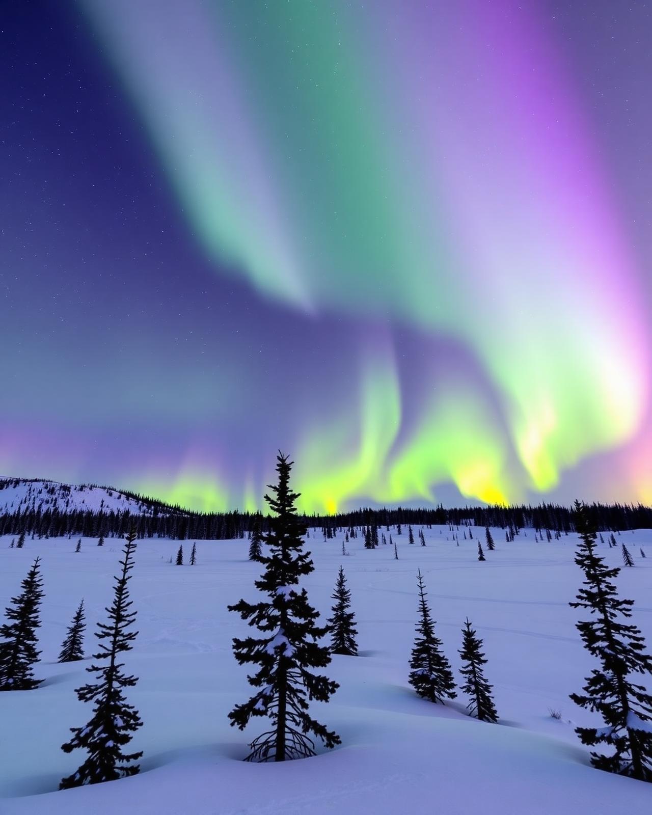
The Dempster Highway is North America's great wilderness road. For 740 km of unpaved gravel, it climbs out of Dawson City, traverses the Tombstone Range, crosses the Arctic Circle, fords the Peel and Mackenzie rivers, and ends in the Inuvialuit hamlet of Inuvik above the tree line. There is nothing else like it.
Completed in 1979 and named for North-West Mounted Police Inspector W.J.D. Dempster, the highway opened the western Arctic to road travel for the first time. Services are spaced by hundreds of kilometres; cell coverage does not exist outside the trailheads. This is a drive that rewards self-sufficiency — a full-size spare, jerry cans of fuel, satellite communication, and a willingness to let weather dictate your pace.
The reward is solitude on a scale most travellers never experience. The Tombstone Territorial Park is a sub-arctic Patagonia of jagged peaks and tundra ridges. The Eagle Plains lodge, at kilometre 369, is the only fuel and food between Dawson City and Fort McPherson. Beyond, the road crosses the Arctic Circle, traverses the Richardson Mountains, and descends into the Mackenzie Delta — a flat green world of channels and lakes that feels closer to Siberia than to Canada.
Distance
740 km
Dawson City → Inuvik
Surface
Unpaved gravel
Calcium chloride sections
Fuel stops
3 between ends
Eagle Plains, Fort McPherson, Tsiigehtchic
Cell coverage
None
Satellite messenger essential
The route
From start to finish
An approximate path through 5 key waypoints along the drive.
Driving times
Leg by leg
740 km across 4 legs. Times exclude stops, ferries, and weather contingencies.
| # | From → To | Distance | Driving time | Notes |
|---|---|---|---|---|
| 01 | Dawson City → Tombstone IC | 70 km | 1h 30m | Paved approach |
| 02 | Tombstone IC → Eagle Plains | 300 km | 4h 30m | Ogilvie + Richardson ridges |
| 03 | Eagle Plains → Fort McPherson | 185 km | 3h 00m | Arctic Circle + Peel ferry |
| 04 | Fort McPherson → Inuvik | 185 km | 3h 00m | Tsiigehtchic Mackenzie ferry |
| Total | 740 km | 12h+ | Drive time only |
Day by day
The itinerary
A suggested route designed to balance driving time with the stops that matter.
Dawson City to Tombstone
Stock up in Dawson City, drive 70 km up the Dempster, and overnight at the Tombstone Interpretive Centre — alpenglow on the peaks at midnight in June.
Tombstone to Eagle Plains
Climb out of the Ogilvie Mountains, cross the Continental Divide, and reach the lonely Eagle Plains lodge at km 369 for fuel and a meal.
Arctic Circle to Fort McPherson
Cross the Arctic Circle at km 405, ferry across the Peel River, and overnight at the Tetlit Gwich'in community of Fort McPherson.
Fort McPherson to Inuvik
Ferry the Mackenzie River at Tsiigehtchic, drive the final 140 km through black spruce forest, and arrive at the Igloo Church in Inuvik.
Inuvik & the Mackenzie Delta
Tour the community, take a flightseeing trip over the delta, or extend on the Inuvik–Tuktoyaktuk Highway for the Arctic Ocean dip.
Return to Dawson City
Retrace the highway south. With practice and confidence, the return drive moves faster — but build in weather contingency.
When to drive
Month by month
Best window: Late June – early September. Plan around shoulder months for fewer crowds at the cost of variable weather.
Budget
Three ways to drive it
Smart
$320–$450/ day
- Drive days
- 6
- Lodging
- Tombstone camping, Eagle Plains motel
- Food
- Self-catered + Eagle Plains diner
- Experiences
- Self-drive + day hikes
Mid
$550–$850/ day
- Drive days
- 6–7
- Lodging
- Inuvik Mackenzie Hotel, Eagle Plains rooms
- Food
- Alestine's Inuvik, lodge meals
- Experiences
- Tundra hike + delta flightseeing
Premium
$1,400+/ day
- Drive days
- 7–10
- Lodging
- Guided expedition + Inuvik suite
- Food
- Catered + Northern Games
- Experiences
- Tuk Highway add-on + Arctic Ocean dip with guide
Editorial picks
Where to stop, sleep, and eat
Operator
Tombstone Park Interpretive Centre
Km 71.5
Daily ranger talks and the only true visitor hub in the first 700 km.
Lodging
Eagle Plains Hotel
Km 369
The only mid-route bed and gas station — book ahead in July.
Operator
Tundra North Tours
Inuvik
Local Inuvialuit-led extensions to Tuktoyaktuk and the Arctic Ocean.
Eat
Alestine's
Inuvik
Outdoor patio with reindeer pizza and Arctic-char tacos.
Signature stops
Don't miss
Tombstone Territorial Park
Arctic Circle crossing
Peel & Mackenzie ferries
Inuvik & the Igloo Church
Before you go
The prep checklist.
Practical things to lock in before you leave the driveway.
- Full-size spare tire + repair kit + tire plug kit minimum.
- Carry two jerry cans of fuel and top up at every station.
- Garmin inReach or equivalent satellite messenger — no cell on the entire route.
- Drive 70–80 km/h on the gravel — faster invites tire failure.
- Build two weather-contingency days; rain can shut the ferries.
Where this road leads
Related destinations
Good to know
Frequently
asked.
Practical answers from travellers who have driven this route.
- Do I need a 4x4 for the Dempster?
- Not strictly — but you need a vehicle with high ground clearance, sturdy all-terrain tires, and at minimum a full-size spare. Many travellers carry two spares. Standard rental sedans are not appropriate.
- When is the highway open?
- The road is technically open year-round, but spring breakup (May) and freeze-up (October) close the ferries and make it impassable. Late June through early September is the realistic window.
- How do I refuel on the route?
- Fuel is available in Dawson City, Eagle Plains (km 369), Fort McPherson (km 555), and Inuvik (km 740). Carry one or two jerry cans for insurance — stations have been known to run dry during peak season.
Planning the bigger trip?
Read our full guide to Canadian road-trip itineraries.
Along this route
Parks, camps, and cities on the drive
Every place below is within a comfortable side-trip of the route waypoints — surfaced automatically from our national-park, provincial-park, campground, and city datasets.
Nearby provincial parks
Nearby campgrounds
Cities along the way
Plan smarter
Related travel guides
Getting Around · 8 min
Getting Around Canada
Flights, trains, road trips, and ferries — how to cross the world's second-largest country.
Read guide →What to Pack · 6 min
Packing by Season
A season-by-season packing list for a country that swings from -40°C in February to +35°C in July.
Read guide →Money & Budget · 5 min
Money, Tipping & Daily Costs
How much to budget per day, how tipping really works, and where to get the best exchange rate.
Read guide →Connectivity · 4 min
Phones, SIMs & Connectivity
How to stay connected without a CAD $300 roaming bill.
Read guide →Keep exploring
Other road trips
Yukon & Alaska
Top of the World Highway
The Yukon River ferry, the highest border crossing in Canada, and one of the most photographed drives in the North.
Explore →Northwest Territories
Ingraham Trail
Yellowknife to Tibbitt Lake — waterfalls, canoe-country lakes, and the Cameron Falls trail 50 km from the capital.
Explore →British Columbia & Yukon
Alaska Highway (Canadian section)
Dawson Creek to the Alaska border via Fort Nelson, Muncho Lake, Liard Hot Springs, and Whitehorse — bison, hot springs, and the Signpost Forest.
Explore →Saskatchewan
Saskatchewan Grasslands Route
Regina to Val Marie via Grasslands National Park and the Cypress Hills — dark-sky preserves, prairie coulees, and the T. rex fossil belt.
Explore →Ready to go?
Plan this road trip with us.
Tell us when you'd like to travel and what you're hoping to experience. A Canadian trip designer will reply within one business day with a custom itinerary built around "Dempster Highway" — no obligation, no pressure.
Free consultation · Reply within 1 business day