The Canadian Explorer
The Canadian ExplorerDiscover Canada · Explore Beyond

Pillar guide

Canada Road Trip Itineraries

Five great Canadian drives, the season for each, and how long they really take — written by people who have driven every one of them.

The complete guide

The best way to see Canada is from a car window. This pillar guide collects our five most-loved Canadian road trips — the Icefields Parkway, Cabot Trail, Sea-to-Sky, Gaspé Peninsula, and Fundy Coastal Drive — with honest pacing, the right season for each, and what to actually stop for.

Why Canada is a road-trip country in the first place

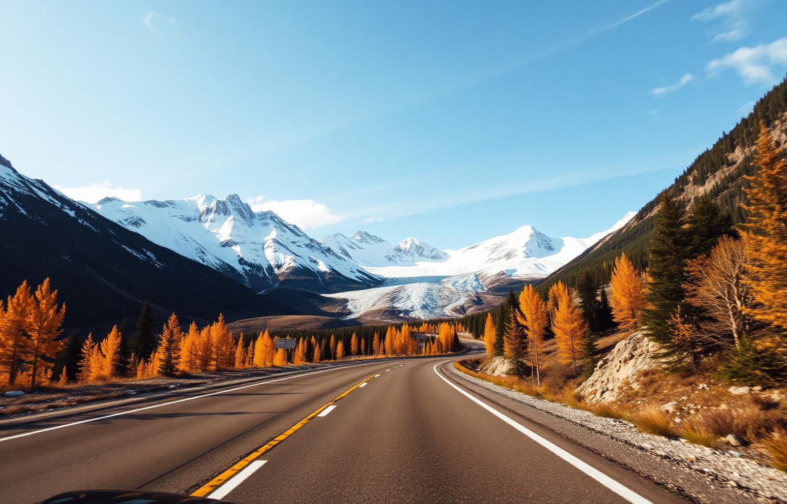
Canada was built for the road. The Trans-Canada Highway runs 7,821 km from St. John's, Newfoundland to Victoria, British Columbia — the longest national highway on Earth. But the drives that define this country are not that one big line; they are the smaller, more deliberate routes that loop around peninsulas, climb through alpine passes, and follow coastlines that almost no one back home has heard of. The Icefields Parkway, the Cabot Trail, the Sea-to-Sky, the Gaspésie loop, the Fundy Coastal Drive — these are five of the great drives anywhere, and they all sit within a single country.

This pillar guide is the one-stop overview. Each of the five drives below has a full detail page with daily distances, recommended overnights, what to stop for, and how long the route really takes when you account for photo stops (the answer is always 'longer than Google Maps suggests'). Use this page to choose which drive fits your trip; use the detail pages to plan it.

1. The Icefields Parkway — 232 km of glaciers and turquoise lakes

If you do one drive in Canada, this is it. The Icefields Parkway (Highway 93N) runs from Lake Louise in Banff National Park to Jasper, threading between the Continental Divide and a wall of icefields that have been retreating but still stop traffic. It is 232 km on paper. Plan two full days minimum — one would be a crime against the landscape.

What to stop for, in order: Bow Lake (with the Num-Ti-Jah lodge in the foreground), Peyto Lake (the wolf-head turquoise everyone has seen and almost no one prepares for), the Big Bend climb, the Columbia Icefield Skywalk, the Athabasca Glacier (you can walk on it with a guided tour, you cannot — do not — walk on it alone), Sunwapta Falls, and Athabasca Falls. Overnight at the Glacier View Lodge or Saskatchewan River Crossing, then arrive in Jasper in time for dinner.

Best time: late June through early September for full access; late September for golden larches and zero crowds (book lodging well ahead — there isn't much). Winter driving is for experienced drivers only — the Parkway is officially open but services are reduced and weather closures are common.

Don't underestimate: there is no fuel for 230 km between Saskatchewan River Crossing and Jasper. Fill up at Lake Louise or the Crossing. Mobile signal is patchy. The Big Bend climb taxes underpowered rentals.

2. The Cabot Trail — 298 km around Cape Breton Island

The Cabot Trail is a 298 km loop around the northern tip of Cape Breton Island in Nova Scotia. It is the closest North America gets to a Scottish Highlands road trip — green mountains falling into the sea, Gaelic place names, fiddle music in the pubs, a national park draped over the spine of the island. Plan three days. Drive it counter-clockwise (start in Baddeck, head north up the western shore, descend the eastern coast through Ingonish) to keep the ocean on your right and the best pull-offs on your side of the road.

Anchor stops: Cheticamp for the Acadian heritage and the start of the Cape Breton Highlands National Park, the Skyline Trail (the most photographed hike in Atlantic Canada — go for sunset), the Pleasant Bay whale-watching boats (minkes and pilot whales reliable, fin whales possible), Meat Cove for the wildest end-of-the-road night you can have in Canada, the Ingonish beaches, and the Gaelic College in St. Ann's on your way back to Baddeck. Eat lobster in Bay St. Lawrence, fresh and unpretentious.

Best time: mid-June through early October. The third week of September into early October is the spectacular foliage window — the maples and birches turn the loop into a colour wheel. Avoid late October onwards: the route is technically open but services close for the season.

Pace: do not drive the full loop in a day. The reason this is one of the great drives is that you stop. Plan five hours of driving across three days, not five hours straight.

3. The Sea-to-Sky Highway — 121 km from Vancouver to Whistler (and beyond)

Highway 99 from Vancouver to Whistler is the rare road trip that is short enough to do in a long weekend and rewarding enough to justify a week. It hugs Howe Sound for the first 50 km — the most consistently beautiful stretch of urban-adjacent coastline in the country — then climbs into the Coast Mountains past Squamish and on to Whistler. Two days minimum. Five if you continue north to Lillooet on the back-road extension that almost no visitors do.

Stops: Shannon Falls and Stawamus Chief (the second-highest granite monolith in the world; if you are fit, do the Chief hike — three peaks, four to six hours), the Sea-to-Sky Gondola for the suspension bridge and rainforest views, Brackendale for winter bald eagle migrations (the largest in North America, December–February), and a slow drift through Whistler Village. Continue past Whistler to Pemberton (potato fields and Lil'wat First Nation cultural centre) and the Joffre Lakes hike for one of the most photographed alpine lakes in BC.

Best time: June through October for the full extension; year-round for Vancouver to Whistler (winter tires required November to April). The first week of October is gorgeous — fall colour against blue water.

Warning: this is one of the most photographed and most driven roads in Canada. Summer Saturdays back up. Drive midweek or start at 7 a.m.

4. The Gaspé Peninsula loop — 885 km of French Atlantic Canada

The Gaspésie loop is the underrated long drive of eastern Canada. From Québec City, you head east along the south shore of the St. Lawrence, round the tip of the Gaspé Peninsula at Forillon National Park and Percé Rock, and return along the Chaleur Bay through Bonaventure and Carleton-sur-Mer. Total 885 km if you do the full loop; we recommend five days minimum, seven if you can.

Why it works: the Gaspé is what eastern Québec looked like a hundred years ago — fishing villages, French signage, dramatic cliffs falling into the sea, and a national park (Forillon) that ends literally at the end of the continent. The classic photograph is Percé Rock at sunrise from the village beach. Bonaventure Island, just offshore, holds one of the largest northern gannet colonies in the world — go.

Best time: mid-June through September. July and August are warmest and busiest; early September is the sweet spot. The route is functionally closed for tourists by November.

What to know: distances are misleading. Routes 132 and 198 along the coast are slow by design — that is the point. Budget 60 km/h average, not 90. Cell coverage drops in pockets through Forillon and parts of the north shore. French is the working language everywhere; in tourist contexts English is fine.

5. The Fundy Coastal Drive — 460 km of the world's highest tides

The Fundy Coastal Drive runs along the New Brunswick shore of the Bay of Fundy — where the tides rise and fall up to 16 metres twice a day, the highest tidal range on Earth. From St. Stephen on the US border, the route runs through St. Andrews, Saint John, the Fundy Trail Parkway, Fundy National Park (Alma), and Hopewell Rocks before climbing on towards Moncton. Four days is right. The drive itself is shorter than the others on this list, but the tides dictate your schedule — you need to time visits to Hopewell Rocks and the ocean floor walks at low tide.

What makes this drive distinct: you can literally walk on the ocean floor at low tide in Alma and at Hopewell Rocks, then return six hours later and the same spot is under 12 metres of water. The Fundy Trail Parkway, opened in stages over the past decade, finally connects St. Martins to Fundy National Park along a wild stretch of coast that until recently was unreachable by car. Allow a full day for the parkway and its lookouts.

Best time: May through October. June and early July have the longest days for tide timing; September is quieter and prices ease. Avoid winter — the route is functionally closed for the season.

Pair it with: Prince Edward Island via the Confederation Bridge from Cape Tormentine (a one-hour add-on at the eastern end). The PEI side adds another four days if you do it well — the National Park beaches, Cavendish, the Anne of Green Gables farmhouse, and the eastern shore lighthouses.

Honourable mentions worth a future trip

Five drives we left off the main list only because they are longer commitments or require more advanced planning. The Dempster Highway in the Yukon — 740 km of gravel from north of Dawson City to Inuvik in the Northwest Territories — is one of the great wilderness drives in North America, but it needs a 4x4 or rental SUV, two spare tires, and a real sense of self-sufficiency. Drive it in late June or early August.

The Viking Trail in Newfoundland (Route 430 from Deer Lake to L'Anse aux Meadows) is a 430 km drive that ends at the only confirmed Norse site in North America, with stops at Gros Morne National Park (a UNESCO World Heritage site) along the way. Five to seven days. The Crowsnest Highway through southern BC links the Rockies to the Okanagan wineries — a quieter alternative to the Trans-Canada for travellers heading east-to-west. The Niagara Parkway from Niagara-on-the-Lake to Fort Erie is short (55 km) but Winston Churchill called it 'the prettiest Sunday afternoon drive in the world' and he wasn't wrong. And the Top of the World Highway from Dawson City into Alaska is one of the most surreal border crossings on Earth — summer only.

The practical bit — renting, fuelling, and driving in Canada

Rent at the airport. The downtown branches in Vancouver, Toronto, Calgary, and Montréal exist but pricing and selection are better at the airport. Book at least two months ahead for summer trips — supply is genuinely constrained in July and August across the country. SUVs are oversold for road conditions; a mid-size sedan is fine for every drive on this list except the Dempster.

Fuel is widely available except on the Icefields Parkway (fill at Lake Louise or Saskatchewan River Crossing), the Dempster (carry jerry cans), and the back-road sections of the Gaspésie. Credit cards work at every pump; pre-authorisation is up to CAD$200, which clears within a few days.

Speed limits are posted in km/h (the Trans-Canada is 100 or 110 km/h in most provinces, 90 km/h in older sections of Atlantic Canada). Distance signs are also in km. Winter tires are legally required from October 1 to April 30 on most BC highways and from December 1 to mid-March in Québec; your rental company defaults to them in those months but confirm. Bear-, moose-, and elk-related accidents are real; do not drive between dusk and dawn through national park corridors if you can avoid it.

How to choose which one

If you have four days: Sea-to-Sky and an extra night in Whistler. If you have a week: Icefields Parkway in the Rockies, with three nights in Banff and two in Jasper. If you have ten days: Cabot Trail combined with Halifax and Lunenburg. If you have two weeks: Fundy + PEI + Cabot Trail as a full Atlantic loop, or Gaspésie + Québec City. If you have three weeks: any of these plus a long-haul rail or flight to a second region.

Whichever one you pick, the same advice applies: stop more than you think you should, leave earlier than you want to, and trust that the country is more interesting at 70 km/h than 110. Use the detail pages below to plan the actual route; come back to this page if you change your mind.

Plan & book

Ready to plan your Canadian road trip?

Our hand-picked partners for stays, tours and park access. Booking through these links helps fund independent guides like this one — at no extra cost to you.

Stays

Compare lodges, inns and small hotels in your Canadian road trip.

Tours & experiences

Small-group tours, day trips and skip-the-line tickets.

Parks pass

The Discovery Pass covers 80+ national parks for a year.

Some links below are affiliate links. We may earn a small commission at no extra cost to you.

Good to know

Frequently
asked.

What is the most scenic road trip in Canada?
The Icefields Parkway between Lake Louise and Jasper is the most consistently cited and the only one most travellers say they wish they had given more days to. The Cabot Trail in Nova Scotia is the strongest contender from the east.
How long does the Icefields Parkway take to drive?
232 km on paper — about three hours non-stop. Plan two full days minimum to actually stop at Bow Lake, Peyto Lake, the Columbia Icefield, Sunwapta Falls, and Athabasca Falls. Three days is better.
Is the Cabot Trail worth the drive?
Yes — but not as a one-day drive. Plan three days minimum. The point of the loop is the stops, the hikes, the whale boats, and the music in Cheticamp and Baddeck.
When is the best time for road trips in Canada?
Mid-June through early October. July–August are busiest and warmest; mid-September is the sweet spot for weather, light, and fewer cars on the road. Winter road trips are possible but limited to specific routes.
Do I need a 4x4 to road trip Canada?
No — except for the Dempster Highway and remote backcountry routes. Every drive on this guide can be done in a mid-size rental sedan with all-season or (in winter) winter tires.
How far in advance should I book accommodation on these routes?
Icefields Parkway and Cabot Trail in July–August: four to six months ahead. Sea-to-Sky and Fundy: six to eight weeks ahead. Off-season everywhere: two weeks is usually fine.